cosmos map
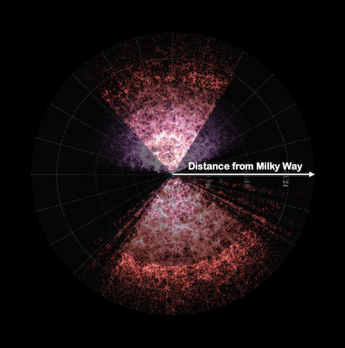
map of our cosmos, Milky Way at the center

This cosmos map shows data from the Sloan Digitial Sky Survey and the 2dF Galaxy Redshift Survey, visualized by Samuel Hinton.

GET STARTED

Click on a blue point above
to fly to the selected galaxy.

Double-click on a blue point
to arrive there immediately.

to estimate the distance to a galaxy:
  1. Rotate the galaxy in the white circle until the longest dimension of the galaxy is vertical
    rotate: hold control + click + drag to the left or right (or use the J–L keys)
  2. Zoom in/out until the galaxy inside the circle (note: not the circle itself) just matches the height of the display
    zoom: scroll in and out (or use the
    I–O keys for finer zoom)
  3. Click on estimate distance

Galaxies and the History of the Universe

height of display

estimated distance
 
zoom: scroll in and out (or use the I–O keys for finer zoom)
rotate: hold control + click + drag to the left or right (or use the J–L keys)
pan: click + drag (or use the W–A–S–D keys)

Overview of Interactive

How do galaxies move within the cosmos? Is there a relationship between the positions of galaxies and how they move relative to us? What can these properties of galaxies tell us about the history of our universe?

In this activity, you will collect your own galaxy data to investigate these questions. You will use real spectra data to measure galaxy velocities and will measure how large or small the galaxies appear in the sky to estimate their distances.

first spectrum
second spectrum
third spectrum
fourth spectrum
fifth spectrum
sixth spectrum
seventh spectrum
eighth spectrum
WorldWide TelescopeAmerican Astronomical Society

© 2020 WWT Ambassadors program. Powered by AAS WorldWide Telescope from the American Astronomical Society, created in collaboration with WGBH for NASA's Bringing the Universe to America's Classroom project under cooperative agreement award no. NNX16AD71A.